![[Clan Crest]](images/Crest%20Colour130.jpg)
Clan MacLea - Livingstone
The Official Home of the Clan McLea (The ancient historical name of the Livingstones)


Early Dalriada
 It is generally accepted that Scots Dalriada was originally founded
at the end of the fifth century by three brothers; Fergus Mor (sometimes
called Mac Nisse Mor), Loarn and Angus. They were sons of Erc, King
of Dál Riata.
It is generally accepted that Scots Dalriada was originally founded
at the end of the fifth century by three brothers; Fergus Mor (sometimes
called Mac Nisse Mor), Loarn and Angus. They were sons of Erc, King
of Dál Riata.
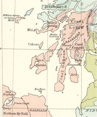
The three kindred groups each had their own rí and territory. The Cenél Óengusa occupied Islay. The Cenél nGabráin, held Kintyre, Cowal, Bute and Arran. The Cenél Loairn held Colonsay as well as present day Lorn and looked on the northern march with the Picts.
I am most interested in the Cenél nGabráin and the Cenél Loairn. There was often conflict between them as each struggled for ascendancy.
Cenél nGabráin and St Columba
The Cenél nGabráin enjoyed the overlordship of Dalriada
for the sixth and much of the seventh century. Columba was involved in
the ordination of Aedán mac Gabráin as overking of Dalriada
in 573.
According to the Irish genealogies, the clan Lachlan, the Lamonds, and
the MacEwans of Otter, were kindred tribes, being descended from Anrothan.
They possessed much of the district of Cowal, from Toward Point to Stacher;
the Lamonds being separated from the MacEwans by the river of Kilfinan,
and the MacEwans from the Maclachlans by the stream which separates the
parishes of Kilfinan and Strath Lachlan.
These lands are all in Cowal. This makes sense as Anrothan gained his
lands by marrying the heiress of Cowal and Knapdale – a Princess
of the Cenél nGabráin.
The Cenél Loairn and St Moluag
The Cenél Loairn eventually gained ascendancy over the Cenél nGabráin, becoming kings of Dalriada, and even high kings of the united kingdoms of the Picts and the Scots. The Cenél Loairn chose as their patron saint, Moluag, who beat Columba to Lismore in 562. Moluag became the patron saint of the Lords of Lorn and the Earls (now Dukes) of Argyll. Once again this tallies as Lismore was within the influence of the Cenél Loairn.
Skene argues that “The northern boundary appears to be represented by a line drawn from the mouth of' Loch Leven through the district of Morvern, separating the old parish of Killiecolmkill - from that of Killfintach, then through the island of Mull by the great ridge of Benmore, and by, the islands of Iona and Colonsay to Isla, where it separated the eastern from the western districts of the island.” He continues “If Iona was exactly on the boundary which separated Dalriada from the Picts, it is obvious how Bede’s statement that it was given 'to Saint Columba by the Picts who inhabit the adjacent districts, is not inconsistent with that of Tighernach, that it was immolated to him by the king of Dalriada.” Other sources state that in the sixth century Conall, son of Comhgall (after whom Cowall is named and where he was appanaged) granted part of Iona to Columba.
In 562 Columba was beaten by Moluag in a race to the large island of the Lyn of Lorn in Argyll . Now called the Isle of Lismore it was the sacred island of the Western Picts and the burial place of their kings whose capital was at Beregonium, across the water at Benderloch.
Although according to Skene’s map Lismore was territorially surrounded by the Cinel Loarn, it was in fact very much no mans land. In 560 King Brude of the Northern Picts had given the Dalriads a drubbing pushing back the borders of the Cinel Loarn to Kintyre . Therefore on Moluag’s arrival in 562 the Dalriads were south of Oban and Brude had taken his army home to Inverness.
There is no evidence to suggest that Moluag was given this land by either party, in fact the story of a race between Moluag and Columba suggests that this is not the case. It is my hypothesis that as Moluag was an Irish Pict, closely allied to the Dalriads he was able to move into this border region with the approval of both factions as a kind of neutral buffer state.
Last updated 20 April, 2013